Our Passion Goes Deep
We bring drill programs back from the brink.
Join mining industry leaders trusting DGI to solve their most pressing geological problems.
Reach outAbout us
Go deeper with DGI
We've spent 25 years proudly innovating data collection for mining, exploration, geotechnical and environmental applications.
Our experienced team designs and implements turn-key data acquisition and interpretation services to meet each project’s specific needs and objectives; whether for exploration, feasibility, production mining or more. Our services play a pivotal role in risk assessment for geotechnical, environmental, and hydrogeological investigations.
Want to learn more?
Reach out

Our passion and expertise are etched in stone
25+
years of service790+
projects, worldwide389006+
surveysIndustry-Leading Results
We've pushed the frontier of slim-hole wireline logging — surveying horizontal and up-dipping holes to 1,000m and stacking probes for simultaneous acquisition.
Services
Mining
- Lithology
- Shear Zone, Foliation
- Joint Characterization
- Fault Zones
- Deviation
- Clay Typing
Geotechnical
- Geotechnical and Civil investigations
- Dam studies
- Identify and delineate underground infrastructure
- Underground disposal
- Cavern and void mapping
Hydrogeological
- Hydraulic Conductivity
- Porosity, Specific Yield, Permeability
- Transmissivity
- Water Quality
- Aquifer mapping
- Quantitative Flowmeter
- Contaminant flows
Petrophysics
- Ore and host rock characterization
- Physical Properties
Break down your barriers to better data


Projects
Go beneath the surface
Testimonials
See how we measure up
"The more we dig into the data provided by DGI borehole surveys, and correlate that information to actual

"The more we dig into the data provided by DGI borehole surveys, and correlate that information to actual mining conditions, the higher the value we see in the information. It is always a challenge to be proactive in forecasting expected ground conditions, especially in deep hard rock mining. Diamond drill scout holes supplemented by DGI geophysical surveys (ATV) to quantify structure and borehole breakout has proven to be one of our best tools."
Use cases
Strengthen your project's foundation

MINING
Surface and underground mines across all commodities, including precious and base metals, diamonds, coal, industrial minerals, and brine mining. Common applications include ore delineation, geotechnical, dewatering, tailings dam, and leach pad optimization.

EXPLORATION
Greenfield and brownfield exploration in all climate extremes. DGI’s equipment is compact and easily transportable by helicopter, cargo, side-by-side, boat, etc. Common applications include structural analysis and ore/alteration zone characterization.

GEOTECHNICAL & CIVIL INFRASTRUCTURE
DGI supports a wide variety of geotechnical drill programs for the mining and civil infrastructure industry. Common applications include fracture analysis, geologic stress analysis, rock burst potential, foundation analysis, and rock mechanical and elastic properties estimation.

HYDROGEOLOGY & ENVIRONMENTAL
Groundwater investigations for traditional and brine mining, infrastructure and municipal projects. Common applications include measuring porosity, pore size and permeability, measuring flow rates under ambient and stressed conditions, and mapping contaminant plumes.
About Us
Meet the experts


Case Studies
See how we've delivered
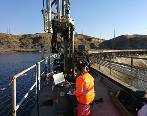
Optical Televiewer surveys at the Rainbow and Ryan Dams near Great Falls, MT
We recently completed Optical Televiewer surveys at the Rainbow and Ryan Dams near Great Falls, MT. The surveys will be used to inspect the concrete, bedrock, and the interface between them. It was a pleasure working for Budinger & Associates on this project, and certainly had one of the better ‘views from the rig’!

Collecting Optical Televiewer data in Arizona
Our colleagues collected 7 different parameters, collecting Optica; televiewer data without destabilizing the hole, using strategic hole conditioning and bit placement.

DGI at SEG 2022 Conference in Denver, Colorado
Don`t forget to visit DGI Booth at all important mining conferences and have a chat with our colleague McLain Pray. Here, during a conversation with partners at the (segweb.org). This year's conference focused on ramping up critical mineral supply to meet the world's demands as humanity goes electric.

Modern technology used to uncover treasures
Our colleagues are also looking for treasures in the underground, with modern technology, using Sonic/Dipole and Bulk Density Logging.